Loading... Please wait...
Categories
Categories
Brands
Brands
- Home
- Moving Map / MFD
- Apollo MX-20 Multi-Function Display / Moving Map
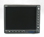
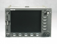
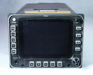
Apollo MX-20 Multi-Function Display / Moving Map


Apollo MX-20 Multi-Function Display / Moving Map
| There is currently a 3-4 week lead time to get an MX-20 certified and ready to ship. |
)

| Part Number: | P/N: 430-0270-000 - MX-20 with internal GPS Receiver |
| Part Number: | P/N: 430-0270-500 - Standard MX-20 |
| Part Number: | P/N: 430-0270-501 - Standard MX-20 |
| Part Number: | P/N: 430-0270-600 - MX-20 I/O with Traffic |
| Part Number: | P/N: 430-0270-700 - MX-20 I/O with Traffic and Radar |
| Condition: | Serviceable (Certified Used) |
| Certification: | 8130-3 |
| Voltage: | 14/28 V |
| Included: | Rack & Connector (if needed), Existing Database |
| Comments: | This is a good MFD, but we can no longer recommend it for new installations, due to a lack of factory support. Any problems can probably not be repaired. |
| Comments: | The best use for an MX-20 is to replace an existing MX-20 if the installation of a different MFD is not an option. |
| Comments: | This is the standard MX-20, without GPS, Traffic, or Radar. These versions are available at extra cost. Please inquire for current availability. |
| Comments: | Like all MX-20 MFDs, this can be upgraded to include Jeppesen's ChartView approach and departure charts, as well as airport surface diagrams. |
Product Description
The MX-20 Multi-Function Display (MFD) will change the way you conduct your flights. By integrating a variety of data, it provides more information, while requiring less interpretation.
The bottom line is that the MX-20 helps you:
- Plan ahead, staying "ahead of the airplane"
- See and avoid hazards
Panel space is valuable, but with an MX-20, this precious "real estate" is put to very good use. More than anything, the MX-20 promotes situational awareness, and that ultimately leads to safer operations. The better you understand your surroundings and options, the better and faster you can make correct and conservative decisions.
The MX-20's core feature is its map, shown on a large 6 inch display (640 x 480 pixels). Great care was taken with the design of the MX-20 to allow you to see the information you want, without inducing "information overload". For example, the map can be set to auto-zoom from waypoint to waypoint in your flight plan. You can scroll the map away from your intended flight path to view surrounding terrain and gather information about passing airports (including properly oriented runway diagrams). There are choices for map orientation, and you can put basic flight data in the corners. If you wish, you can see airways, water, roads, borders, and obstructions.
Perhaps even better, you can see your GPS-derived position and progress on either an IFR or VFR chart. You may also add the optional Jeppesen ChartView database. This shows your georeferenced position on approach and departure charts. ChartView also pinpoints your location on airport surface diagrams (displaying automatically upon landing when your groundspeed slows sufficiently). This is a great help when navigating unfamiliar airports, and helps prevent runway incursions.
The MX-20 knows your altitude, because it is connected to your blind encoder (also used for Mode C). When you update your altimeter setting, you also tell the MX-20 the current pressure. The MX-20 then compares your altitude and known position against a terrain database, and color-codes the surrounding terrain based on the altitude difference:
| Color | Relative Altitude |
| Black | More than 2,000 feet below |
| Green | Within 2,000 feet |
| Yellow | Within 500 feet |
| Red | At or above current altitude |
There are two ways the MX-20 can display weather information. Either way, the weather is shown in relation to your position and flight plan, so you can clearly see the potential effect on your plan. If you have an L3 WX-500 Stormscope or an Avidyne TWX-670, the electrical discharges will display on the map. If you have a Garmin GDL-69 or GDL-69A, the MX-20 will show the following from XM weather:
- NEXRAD Radar
- Lightning
- Satellite Imagery
- METARs
- Winds Aloft
- Freezing Level
The MX-20 communicates with an external GPS via a standard RS-232 serial interface. The MX-20 is 5 inches tall, and a standard radio stack width (6.25 inches).
You may also be interested in a GPS to provide position information for this Multi-Function Display.
If you have any questions about this item, please:
- Call: 860-653-7295
- Click:
 to send us an email.