 Loading... Please wait...
Categories
Categories
Brands
Brands
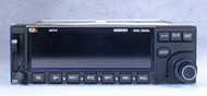
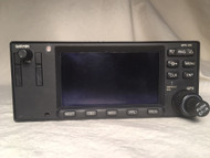
GPS-150XL VFR GPS / Moving Map


)

| Part Number: | P/N: 011-00345-00 |
| Condition: | Serviceable (Certified Used) |
| Certification: | 8130-3 |
| Voltage: | 14/28 V |
| Included: | 90 Day Warranty |
| Included: | GPS Antenna, Rack, Connector, Existing Database available at extra cost if needed |
| Comments: | The GPS-150XL is still a very good VFR GPS, but it is no longer supported by the factory. We still repair these radios, but we no longer have the ability to order parts from Garmin. |
| Comments: | Some of our GPS-150XL sales are for customers who are replacing another GPS-150XL. These customers do not need the GPS antenna, mounting rack, connectors, or database, and we do not want to charge them for items they do not need. |
| Comments: | If you need these items for a new installation, please choose "Yes" in response to the "Need Installation Hardware" question. |
Product Description
The GPS-150XL is a very good VFR GPS-only product. If you do not need IFR capability, a COMM transceiver built in to your GPS, or a color display, this is as good as it gets!
The GPS-150XL provides all the features you would expect in a VFR GPS, including a comprehensive database. It differs from its popular GPS-150 predecessor by featuring a very sharp, high-resolution display. This display pays dividends on both text and the moving map graphics. Please be sure to view the Garmin GPS-150XL Brochure Picture below, since words do not do this display justice.
The Garmin GPS-150XL features:
- Very sharp LCD display - This display measures 240 pixels wide by 80 pixels high. This resolution is good enough to allow curved lines to appear smooth, and the text to be razor sharp. A wide viewing angle makes it clearly visible from either front seat. The brightness of this display is controlled automatically to match lighting conditions, and information can be displayed as either yellow on black or black on yellow. This display can be set up to show a moving map, navigation information, and a built-in electronic CDI.
- Moving Map graphics - The very high definition moving map shows your aircraft's position relative to surrounding waypoints, navaids, SUA, runways, and other database items. The map has 14 map scales from .5 to 300 NM, and an autozoom feature can be used to keep both your present position and destination on the map. This moving map may be oriented with ground track up, course (desired track) up, or north up. Even with the map displayed, you are still shown the distance to current waypoint, ground speed, bearing, desired track, and ETE. Map decluttering is available by item or scale, to prevent information overload.
- Ease of use - The GPS-150XL is designed to minimize keystrokes in operation, and operate with a clear, consistent user interface. This GPS provides very sophisticated navigation features, but common functions are readily available. For example, the Direct-To key lets you instantly set course to any waypoint you select.
- Pilot-focused design - The GPS-150XL is packed with features designed to make a pilot's job easier. The planning function helps determine trip length, fuel requirements, and vertical navigation (VNAV) profiles. The computer performs true airspeed, density altitude, winds aloft, and sunrise /sunset calculations. The pilot may store up to 20 reversible flight plans of 30 legs each. Up to 1000 pilot defined waypoints may be added to the database, and there is a 40 character comments field for up to 250 of these waypoints. There are 9 user-definable checklists of up to 30 items each. Finally, alarms remind the pilot of arrival, proximity, countdown timers, and SUA penetration in 10 minutes, 2NM, and inside SUA.
- Peace of mind - An Nearest function quickly displays the 9 nearest airports, VORs, NDBs, intersections, and user-defined waypoints. Even better, the pilot may set airport search criteria based on runway length. The GPS-150XL will also provide you with the 2 nearest FSS and ARTCC frequencies, based on your current position.
- Datacard database - The Jeppesen database includes information for airports, VORs, NDBs, intersections, COMM frequencies, runways, FSS/ARTCC, MSA, and SUA. The database card is front loading, which makes it much easier to keep the data up-to-date.
- Compatibility - The Garmin GPS-150XL may be interfaced with an HSI, CDI, Autopilot, Blind Encoder, Fuel Sensor, and Fuel/Air Data Computer.
The GPS-150XL provides non-precision guidance, without vertical information. Unless this GPS shares an Indicator which provides Glideslope, it is typically paired with a non-Glideslope Indicator:
- King KI-202 GPS/VOR/LOC Indicator
- Garmin GI-102A GPS/VOR/LOC Indicator
- Collins IND-350A GPS/VOR/LOC Indicator (later model with more durable metal case)
- Collins IND-350 GPS/VOR/LOC Indicator (not recommended)
If you have any questions about this item, please:
- Call: 860-653-7295
- Click:
 to send us an email.
Warranty Information
Product Reviews
Find Similar Products by Category
Related Products
-
-
 KLN-35A VFR GPS / Moving Map $1,695.00
-
 KLN-89 VFR GPS / Moving Map $1,295.00
-
-
 GPS-400 IFR-Approach GPS / Moving Map $2,995.00

