Categories
Categories
Brands
Brands
- Home
- Discontinued Products
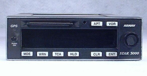
- STAR 5000 VFR GPS Navigator
STAR 5000 VFR GPS Navigator
Contact us for price (sales@bennettavionics.com, 860-653-7295)
Product Information
| Part Number: | P/N: 453-1060-00 |
| Part Number: | P/N: 453-1060-01 - Standard STAR 5000 |
| Condition: | Serviceable (Certified Used) |
| Certification: | 8130-3 |
| Voltage: | 14/28 V |
| Included: | GPS Antenna, Rack, Connector, Existing Database, 90 Day Warranty |
| Comments: | Sagem Avionics (who purchased ARNAV) terminated factory support of the STAR 5000 at the end of 2010. As a result, we can no longer recommend this GPS. |
| Comments: | The STAR 5000 is an abandoned product, and we do not expect to have more of them in the future. |
Product Description
You already know that you want to add a GPS to your aircraft, but why should you choose the ARNAV STAR 5000 GPS Navigator? The reason is simply that the STAR 5000 offers both performance and value. Designed by pilots for pilots, the STAR 5000 is extremely powerful, yet still easy to use.
When using the STAR 5000, you can navigate to any position in the world with 50 foot accuracy. All the standard GPS calculations are here, including bearing, distance, ETE, ETA, ground speed, ground track, and much more.
The STAR 5000 offers many great features, including:
- Automatic GPS satellite selection that ensures the best position fix at all times
- A large, bright, 40-character LED display that can be read at a glance in any light condition
- Easy operation - One turn-and-push knob locates all airports, VORs, NDBs, intersections, and user-created waypoints and flight plans
- Logical completion of waypoint ID - No need to enter the full identifier or city name for airports, VORs, NDBs, or user waypoints
- "Near-To" search for when the waypoint identifier or city location is unknown, but another airport, VOR, NDB, intersection, user-defined waypoint, or city is known in the vicinity
- Flight planning that lets you create and store multiple routes containing up to 25 waypoints each
- 40,000 waypoint NavData card with Jeppesen data
- "Local Waypoint" search that lets you view information about the 15 closest airports, VORs, and intersections around your present position
- Capable of interfacing with your HSI, CDI, and Autopilot (Even though this GPS does not have an internal Moving Map, it may be used to provide position information to an external Moving Map.)
 to send us an email.
 Loading... Please wait...


