Loading... Please wait...
Categories
Categories
Brands
Brands
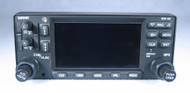
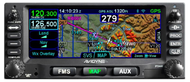
GTN-650 WAAS IFR GPS / NAV / COMM / MFD / Moving Map / Glideslope


)

| Part Number: | P/N: 011-02256-00 - Black faceplate |
| Part Number: | P/N: 011-02256-50 - Gray faceplate |
| Condition: | Serviceable (Certified Used) |
| Certification: | 8130-3 |
| Voltage: | 14/28 V |
| Included: | GPS Antenna, Rack, Connector, Existing Database, 6 Month Warranty |
| Comments: | This WAAS Receiver is compatible with the European EGNOS and Asian MSAS precision GPS systems. |
Product Description
The GTN-650, which is the next-generation version of the GNS-430W, will serve as the hub of your avionics. The Navigation and Communication functions are more powerful, but also easier to use. The Multi-Function Display (MFD) capabilities are enhanced considerably, especially when paired with an ADS-B In Receiver.
Most of the GTN-650's features, including a high-resolution moving map, graphical flight planning, terrain avoidance, traffic alerts, weather information, and taxiway diagrams, are made possible by the larger 4.9" color display with a touch interface.
The GTN-650 has a significantly larger and higher-resolution display than the GNS-430W. It has a "pinch and zoom" touch interface, similar to a smartphone. (Some pilots love the touch interface, and others miss the traditional buttons and knobs.) Raised bezels offer a physical connection to "anchor" the pilot's hand during operation.
The GTN-650 includes a tremendous amount of capability, and these are only the highlights. (Please send us an email if you would like the Pilot's Guide, and we will be happy to send you a copy for your review.)
Navigation
The GTN-650 will allow WAAS-GPS-enabled precision IFR LPV approaches, in addition to standard VOR / Localizer / Glideslope navigation.
There are thousands of FAA-approved LPV WAAS approaches, with more being added regularly. The FAA's stated goal is to have a WAAS approach available for every public runway at least 3,200 feet long. To see if the airports you use offer WAAS capability, please click here for the FAA's information about GPS/WAAS Approaches.
One of the admired features of the CNX-80/GNS-480 is the ability to navigate with Victor airways. The GNS-430W and GNS-530W lack this feature, but it is present in the GTN-650.
Even when flying VFR, the GTN-650 can create a virtual precision approach, with vertical guidance. The keys to safety are consistency and precision, and this feature allows you to treat a VFR approach like an IFR approach.
Communication
The COMM frequencies may be tuned in either 25 kHz or 8.33 kHz increments. The 8.33 kHz channel spacing is critical to meeting European requirements.
The GTN-650 will decode the Morse code identifier automatically. It will also display the identifier from the database, confirming you are communicating with the correct party.
It is quick and easy to call for help. When the pilot holds down the volume knob or remote active/standby flip-flop switch for two seconds, the GTN-650 will automatically set the emergency frequency (121.5 MHz) as your active frequency. When you are busy and time is important, just hold down the knob and key the mic to get help.
Multi-Function Display (MFD)
The GTN-650 has a high-resolution Moving Map, capable of showing Topographical features, Victor Airways, Terrain (color-coded relative to your current altitude), Weather Radar, WX-500 Stormscope Lightning (if equipped), and Traffic. Please note that Terrain and Weather Radar information cannot be shown at the same time. Both types of information are color-coded according to the relative threat, and it would be confusing to see "red" same-altitude terrain and "red" high-intensity precipitation at the same time.
Traffic information is available on a dedicated page. But if you are viewing other information on the MFD, a pop-up window will still bring traffic information to your attention.
It is possible to "pan" the map to a different region simply by dragging your finger across the display, much as you would a smartphone or tablet.
Garmin's SafeTaxi database is available to show runways, taxiways, FBOs, and hangars on the display. This boosts safety by allowing the pilot to ensure they are following the Ground instructions. (It also makes it more difficult to get lost at an unfamiliar airport!) The MFD will also show "Hot Spots", which are confusing or complicated areas where extra care is needed for safety.
If you also have ADS-B In, the GTN-650 can display up to 60 traffic targets with both audio and visual alerts. Subscription-free ADS-B In weather information includes NEXRAD radar, graphical AIRMET, Winds & Temperature Aloft, Lightning, Turbulence, Icing, Cloud Tops, and much more.
Convenience
The GTN-650 feels similar to the GNS-430W in operation, but a "flattened" menu structure makes it faster and easier to reach the function you need.
If you have a second GTN-series radio, or a GNS-430W / GNS-530W, they are able to communicate and share the active flight plan.
The GTN-650 will show you the entire planned flight on the moving map. When the inevitable changes are introduced, the "rubber band" feature allows you to drag any segment of your route to match the new clearance.
As a WAAS GPS, the GTN-650 is able to serve as the position source for your ADS-B Out solution.
The GTN-650 has the ability to control a remotely-mounted Transponder, saving space in your radio stack.
The GTN-650 is very flexible, and may be used with these Glideslope Indicators, HSIs, and Glass Panels (the Garmin units are the official choices):
- Garmin GI-106A GPS/VOR/LOC/Glideslope Indicator
- Garmin GI-106B GPS/VOR/LOC/Glideslope Indicator
- Mid-Continent MD200-306 GPS/VOR/LOC/Glideslope Indicator
- Mid-Continent MD200-706 GPS/VOR/LOC/Glideslope Indicator
- Collins IND-351A GPS/VOR/LOC/Glideslope Indicator
- King KI-204 VOR / LOC / Glideslope Indicator
- King KI-206 GPS/VOR/LOC/Glideslope Indicator
- King KI-209 VOR / LOC / Glideslope Indicator
- King KI-209A GPS/VOR/LOC/Glideslope Indicator
- King KNI-520 GPS/VOR/LOC/Glideslope Indicator
- King KI-525/525A HSI (part of a KCS-55/55A system)
- Century NSD-360A Slaved Compass System (HSI)
- Sandel SN-3308 Electronic HSI (EHSI)
- Garmin G5, G500, G500H, G500 TXi, G600, G600 TXi, or G3X Glass Panels
If you have any questions about this item, please:
- Call: 860-653-7295
- Click:
 to send us an email.